
SURVEY AND GIS SOLUTIONS
NOC SURVEY AIRPORT/AIRFORCE
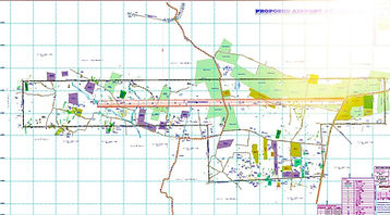
MOD/AAI SURVEY WIND TURBINE/POWER PROJECTS
TOPOGRAPHIC SURVEY
HELIDECK/HELIPAD/AIRPORT
OBSTACLE LIMITATION SURVEY
SERVICES


WHO WE ARE
TopNav Spatial Solutions Pvt Ltd Established in the year 2019 has been providing surveying services all over india. Our capabilities include NOC Survey for Airport/Airforce, Topographic survey, Helideck survey, Helipad survey.
We consider our clients to be more than just the people with whom we do business. They are valued partners. We make every effort to listen to our client's need and recognize what is individually important to them.
Under the leadership of our Founder & Managing Director Mr. Dhanasekar and Director Mr. Virender Singh, we have grown tremendously as a recognizable company providing quality services. Both directors have more than 20 years of experience in the survey and Aviation industry.
WHAT WE DO
We use the ‘state of the art’ advanced technology dual frequency DGPS (Differential Global Positioning / GNSS System), Total Station, customized GIS solution. We offer our cost effective quality services to Government, Semi Government, Private Organizations & Corporates all over the globe, with high speed and best in class accuracy.
Surveying is at the core of what “TOPNAV” does. We began originally as a surveying-only firm and today that focus prevails in many of our projects, though we have expanded to many other areas of service.
Our team consists of professional surveyors and skilled crews with the experience and knowledge to complete your project successfully.
2023
Year Established
206
Projects Completed
870
Contractors Appointed
26
Awards Won
PROJECTS


SERVICES
NOC Survey for the construction of high-rise buildings
We undertake survey for obtaining NOC for height clearance from AAI / IAF, for constructing high raised buildings and skyscrapers.
For high-raised structures, such as buildings, masts, chimney and billboard etc. is around an existing or a proposed airport, an NOC from the AAI and/or defence authority (if it is a defence airport) is imperative.

Airports Authority of India has introduced NOCAS, NO Objection Certificate Application System, to accept online applications for height clearance for the structures for Safeguarding the Airspace in and around the civil airports as per the rules laid down in GSR 751 (E), issued by MoCA on 30th September, 2015.
For the Defence Airports, responsibility is with the respective Defence Authorities.
We do an AMSL/RL survey with the help of DGPS and Total Station. The required Airport zoning map locating the proposed construction site is prepared by us. This map along with other drawings such as, site layout drawing, building elevation plan and other mandatory documents are obtained from the customer and the application is submitted to AAI, through AAI’s official web portal. In case of defence airport, the application is submitted to the concerned defence authority.

-
We do continue followup with the concerned authorities and assist the applicant to obtain the NOC. Thus we undertake the complete Liasioning for obtaining NOC for height clearance.
-
Thus in turn we assist in avoiding future obstacles to ensure a safe airspace.
Topographic Survey
A Topographic Survey is a survey that gathers data about the elevation of points on a piece of land and presents them as contour lines on a plot. The purpose of a topographic survey is to collect survey data about the natural and man-made features of the land, as well as its elevations. Topographic maps are used to show elevations and grading features for architects, engineers, and building contractors.
Our professional land surveying team is well-versed in the nuances of topographic surveying. Utilizing the latest surveying technology, Our Professional surveyors produce accurate, consistently reliable topographic surveys, saving you both time and money during the construction process.
You can trust “TOPNAV” to provide all your land surveying needs promptly and professionally.

Charting
At TOPNAV we also prepare detailed topo map and contour map which helps client to take major decisions especially developing structure inside proposed airports.
Obstacle Limitation Survey
Helideck/Helipad
We conduct OLS Survey for Existing/Proposed Helipad and Helideck as per ICAO / CAAP 437 standards.
This is basically a field survey and the data obtained after survey provides Helideck/Helipad geodetic control, TLOF, Visual aids,obstruction and other parameters that are critical to the Helicopter operations. The data were used for analysis like obstacle analysis, verification of Physical layout of helideck/Helipad, facilities design and prepare charts.
Our professional surveying team is well-versed in the nuances of Helideck/Helipad surveying. Utilizing the latest surveying technology, Our Professional surveyors produce accurate, consistently reliable Helideck/Helipad surveys, saving you both time and money during the construction process.
You can trust “TOPNAV” to provide all your surveying needs promptly and professionally

NOC for Construction of Power Projects /Wind
Turbine Generators/Solar Power projects
As per the Guidelines NOC for Construction of Power Projects/Wind Turbine Generators/Solar
Power Projects (except solar power modules at the top of building for domestic usage) is required
to be obtain from Ministry of Defence.
The NOC is proposed by various government agencies /autonomous bodies for Power projects
and also by private agencies/individuals for private Power Projects As per the existing
procedure, applications for grant of NoC are forwarded by stakeholders ministry/organization to
Ministry of Defence ( for their recommendations Bases on the inputs of the concerned
authorities, the Ministry of Defence decides upon grant/refusal of NoC for such Power Projects
The newly developed MoD web portal is aimed at facilitating the vendors for submission of
applications online for grant of No Objection Certificate for Construction of Power Projects/Wind
Turbine Generators/Solar Power Projects (except solar power modules at the top of building for
domestic usage) The automated/online system will help in reducing the time, bringing in more
transparency, accuracy and speedy disposal of applications for grant of NoC by MoD The
latitude/ longitude for each of application should be clearly mentioned in application for ease in
locating the items on ground


-
We do continue followup with the concerned authorities and assist the applicant to obtain the MOD/AAI. Thus we undertake the complete Liasioning for obtaining NOC for height clearance.
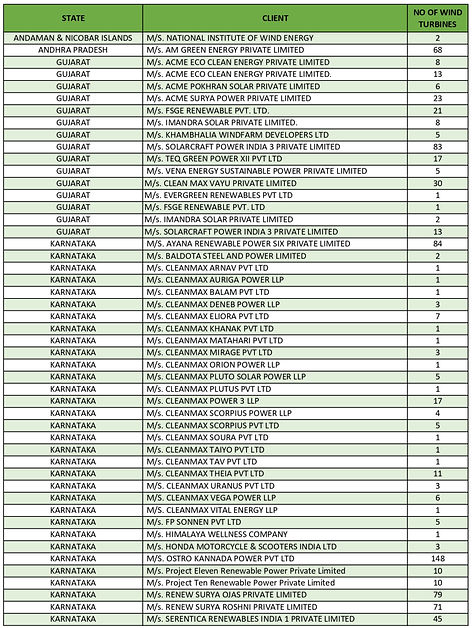
CLIENTS


CONTACT
Inquiries
For any inquiries, questions or commendations, please call: +91.9841033844 or fill out the following form
Contact Us
Head Office
Sri Balaji ‘s Residency
No. 3A Third Floor
Plot No. 88, Vijaya Nagar Extension
Gomathy Nagar,
Velachery- Chennai - 600042
Tel: +91.9841033844
Get a quote: +91.9841033844